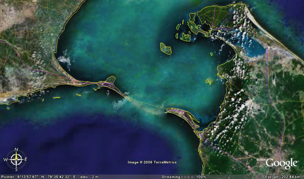
Take a look at this picture on the right taken from Google Earth (Click photo to enlarge). Look below the yellow line joining Indian and Sri Lanka. If you look carefully, you will find a cluster of rocks creating a bridge like formation connecting these two countries. This is known in the modern world as Adam’s Bridge though the Indians also know it as Ram’s Bridge. Some more pictures of this bridge can be found here.Legend has it that when Ram was going on the conquest of Lanka, the demonic kingdom, he had to build a bridge to link the Indian mainland with Lanka. He with the help of the army of monkeys built a bridge of rocks under the supervision of Nala, son of the architect-god Vishwakarma. The bridge of rocks was supposed to float on water but the gods anchored it to the sea bed, thus forming a cluster as is seen from the satellite image.
Most Hindu groups claim it as fool-proof evidence of the fact that the events described in Ramayan actually took place and scoff at claims of scholars that Ramayan and Mahabharat were nothing more than fictional stories.
Some may ask why this mythical bridge is known as Adam’s Bridge when it is claimed to have been built by Ram. The answer can be found in Christian mythology which believes that the biblical Garden of Eden was located in modern day Sri Lanka.
Archaeological studies of the area around the bridge are still under progress and some archaeologists claim that the bridge is no more than 3500 years old. Some studies have found that sea levels in this region rose by up to 20 metres to reach the level of today, thus corroborating the above theory. This 30km long stretch is being regarded as the oldest evidence of a man-made structure across the sea.


Writer was commented upon by